I've had a lot of problems with FATAL ERRORS lately within my grading projects. It seems like after a few days of editing and re-editing the grading file, the drawing comes to a point of critical mass where the internal errors start stacking up. If you run the "AUDIT" command, you'll see. But it doesn't seem like AUDIT ever repairs the errors it finds as it reports. And sometimes there comes a point where you can't even run AUDIT or even save the drawing, which renders the drawing session useless. I can't remember right now the exact error message in the dialog. I'll make sure I post a screen cap next time it happens. But I do know that when that dialog appears, you can do nothing except CTRL-ALT-DEL out and end the AutoCAD session with no save. Then restore your last previously saved file. Not fun.
I don't have any magic remedy for this here. The advice I received from Autodesk was to take the previously saved drawing, run "-PURGE", then run "AUDIT". Works for a little while until I get the previously mentioned dialog box again. It usually happens within a few minutes of editing the drawing, usually when editing a feature line or grading.
So what I've done is to redefine the "QSAVE" command to run "AUDIT" before the save. This seems to help cut down on errors created by editing feature lines, gradings, etc. I use this QSAVE often when editing grading files, especially before a "major" edit.
Here is the simple AutoLISP code that you may copy to a .lsp file, then load into your startup application suite "APPLOAD".
(command "_undefine" "_QSAVE")
(defun C:QSAVE()
(command "audit" "Y")
(command "_.QSAVE")
(princ))
Thursday, November 06, 2008


Tuesday, June 17, 2008
Civil 3D 2009 - Missing Arrowheads
Are you missing arrowheads on dimensions, as in can't see them on-screen or can't plot them? Then more than likely you're also using Raster Design with Civil 3D 2009, right? Autodesk has issued a HotFix for this bug. It can be found at Solid Filled Filled Hotfix.
Civil 3D 2009 Network Deployment Install Issue
I ran across this yesterday while helping out one of my co-workers. Civil 3D 2009 will not install from a network deployment if Autodesk DWF Viewer 6.5 or prior is installed. The Hydroflow products and the Survey Link install, but then the setup ends suddenly and without warning. We didn't know what the issue was until we tried installing C3D directly from the DVD. The DVD setup showed that the install could not continue without uninstalling DWF Viewer 6.5. It worked fine after that.
Friday, December 07, 2007
Sick all week at AU
Well my AU this year was a wasted week. Tuesday night I acquired what can be called "Montezuma's Revenge - Las Vegas style". I was laid up in my hotel room from Wednesday morning for the remainder of my stay until Sunday night when I left. The stomach bacterial battle of my life. And my poor wife flew in Friday to have a fun weekend but I was in no mood. Furthermore, she got what I had when we got back home on Monday and has been fighting the beast virus all week with me.
So needless to say my week in Vegas was a complete waste besides giving the lame healthcare providers in the city my $50 co-pays for 2 emergency urgent care visits and helping to keep Walgreens pharmacy on the south strip in business.
So for those of you who I meant to meet during the week, sorry, maybe next time when AU is NOT in Vegas. Maybe one year it can be held on the east coast again.
At least I got a wizard's hat at the subscription booth Tuesday night. That was my highlight.
So needless to say my week in Vegas was a complete waste besides giving the lame healthcare providers in the city my $50 co-pays for 2 emergency urgent care visits and helping to keep Walgreens pharmacy on the south strip in business.
So for those of you who I meant to meet during the week, sorry, maybe next time when AU is NOT in Vegas. Maybe one year it can be held on the east coast again.
At least I got a wizard's hat at the subscription booth Tuesday night. That was my highlight.
Thursday, November 08, 2007
Single Drawing Compatibility Mode in 2008
Earlier this week one of my co-workers had a problem after they had crashed out of Civil 3D. When he reopened AutoCAD, he could only open one drawing at a time. Well this was familar, but where to go change the setting back was not. In older AutoCAD versions prior to 2007, there was an area in OPTIONS to toggle Single Drawing Compatibilty Mode off and on. Well, in 2008 this does not exist in OPTIONS. You can toggle this mode by typing SDI at the Command line and change it to either 0 or 1. Setting to 0 enables you to have multiple drawings open (default).
So if for some reason if you have a fatal error in C3D (which BTW is becoming less frequent of an occurance with SP2 applied) and you find that you can only open 1 drawing at a time, then check the SDI setting.
So if for some reason if you have a fatal error in C3D (which BTW is becoming less frequent of an occurance with SP2 applied) and you find that you can only open 1 drawing at a time, then check the SDI setting.
Monday, June 25, 2007
Annotative Scales - "XREF XREF XREF etc..."
Have you seen this problem in 2008 with the annotative scales list?
Click pic to see a larger view...

Good grief... As we bring our 2007 AutoCAD drawings into the 2008 world and xref them into new drawings, the annotative scales list becomes outrageously HUGE! The list becomes so large over time that the dialog box for the "SCALELISTEDIT" command will not even open.
But there is a solution. You can use the command "-SCALELISTEDIT" to (R)eset the list to the original preset list. Don't forget the "-" dash before the command; this will temporarily disable the dialog box and forces command line prompting. Doing this removes the unwanted "Xref" scales and restores the original scales list. Thanks to Almas at Autodesk for the support tip.
I've actually added a line to the S::STARTUP section of my ACAD.lsp file to automatically delete (reset) the scales for me. Here's the LISP string
(command "-scalelistedit" "r" "y" "e")
Happy annotating!
Click pic to see a larger view...

Good grief... As we bring our 2007 AutoCAD drawings into the 2008 world and xref them into new drawings, the annotative scales list becomes outrageously HUGE! The list becomes so large over time that the dialog box for the "SCALELISTEDIT" command will not even open.
But there is a solution. You can use the command "-SCALELISTEDIT" to (R)eset the list to the original preset list. Don't forget the "-" dash before the command; this will temporarily disable the dialog box and forces command line prompting. Doing this removes the unwanted "Xref" scales and restores the original scales list. Thanks to Almas at Autodesk for the support tip.
I've actually added a line to the S::STARTUP section of my ACAD.lsp file to automatically delete (reset) the scales for me. Here's the LISP string
(command "-scalelistedit" "r" "y" "e")
Happy annotating!
Friday, June 01, 2007
C3D 2008 Workaround - Contour labels will not update
In 2008, when you edit a surface that has contour labels applied, the labels do not update automatically. This issue has been submitted to Autodesk and is a known issue. To update the labels, you have to move or grip-edit-move each individual label line. Rebuilding the surface or regenerating the drawing does not help.
I have developed a very simple LISP routine which will move the label lines for you all at once. The routine assumes that Contour Label Lines are being drawn on layer "C-TOPO-TEXT".
Also be aware that by using this routine, anything else on layer "C-TOPO-TEXT" will be MOVED @ X=0.001 , Y=0.001.
You may revise my program to fit your needs.
Download here: UL.lsp - update labels (contours)
I have developed a very simple LISP routine which will move the label lines for you all at once. The routine assumes that Contour Label Lines are being drawn on layer "C-TOPO-TEXT".
Also be aware that by using this routine, anything else on layer "C-TOPO-TEXT" will be MOVED @ X=0.001 , Y=0.001.
You may revise my program to fit your needs.
Download here: UL.lsp - update labels (contours)
Civil 3D 2008 Bug List
Thanks to James Wedding and his colleagues at Civil3D.com for creating a running list of Civil 3D 2008 bugs and issues. The list can be found at http://www.civil3d.com/index.php/2007/06/whats-bugging-you-about-2008/. This list will help us determine if a problem that we find while using C3D '08 in our everyday work life has been identified by others as well.
Thursday, March 22, 2007
Off-topic - Personality Type and Blogging
The description listed below is pretty much me when it comes to blogging. I tested as an ISTP recently in an online Jung - Myers-Brigg personality type test. I took a similar test for work about 17 years ago and tested as an ISTJ but I must have changed a little over the years. The 2 types have similar traits so I guess I haven't changed much except for a few extra pounds around the mid-section. See opinions about how blogging ties in with personality types HERE.
Here's my profile:
You are an ISTP! (that's me)
As an ISTP, you are Intraverted, Sensing, Thinking, Perceiving. This makes your primary focus on Introverted Thinking with Extraverted Sensing
This is defined as a SP personality, which is part of Carl Jung's Artisans (Sensation Seeking) type, and more specifically the Crafters or Mechanics.
Because of your desire for action and independance, you will change the format of blogging or design frequently to keep it interesting and different. Your loyalty may have you reading the same blogs over a long period of time (Civil3D.com, Angel's Civil 3D Thoughts are 2 that come to mind). Even though you could be easily bored with blogging (and Windows XP, that's why I bought Vista), you might find that because you like following a project through, this is a good way for you to use your alone time to sort the facts you pick up through the day. (exactly me!)
Take the test for yourself, then see how you might relate to blogging HERE.
Here's my profile:
You are an ISTP! (that's me)
As an ISTP, you are Intraverted, Sensing, Thinking, Perceiving. This makes your primary focus on Introverted Thinking with Extraverted Sensing
This is defined as a SP personality, which is part of Carl Jung's Artisans (Sensation Seeking) type, and more specifically the Crafters or Mechanics.
Because of your desire for action and independance, you will change the format of blogging or design frequently to keep it interesting and different. Your loyalty may have you reading the same blogs over a long period of time (Civil3D.com, Angel's Civil 3D Thoughts are 2 that come to mind). Even though you could be easily bored with blogging (and Windows XP, that's why I bought Vista), you might find that because you like following a project through, this is a good way for you to use your alone time to sort the facts you pick up through the day. (exactly me!)
Take the test for yourself, then see how you might relate to blogging HERE.
Tuesday, February 20, 2007
...and concerning Windows Vista
Plain and simple, Windows Vista is a DOG!!! It could be the worst performing operating system Microsoft has produced...period. It takes a ultra capable Core 2 Duo processing unit and makes it a door stop. You will need a minimum of 2 GB of RAM just to run the base OS effectively. That's before trying to run any applications. 1 GB just doesn't cut it anymore. I have a Pentium 1, 166 Mhz laptop that boots Windows 98 in half the time. Ridiculous.
And as for Civil 3D running on Vista...well I am a glutton for punishment but I actually had it working until I applied Service Pack 3. Now I get a Fatal Error when trying to open the program. I read in Heidi Hewitt's blog that Autodesk is working on a patch for AutoCAD 2007 and Windows Vista. But even with a patch, stay with Windows XP / Pro. You'll be glad you did.
And as for Civil 3D running on Vista...well I am a glutton for punishment but I actually had it working until I applied Service Pack 3. Now I get a Fatal Error when trying to open the program. I read in Heidi Hewitt's blog that Autodesk is working on a patch for AutoCAD 2007 and Windows Vista. But even with a patch, stay with Windows XP / Pro. You'll be glad you did.
AutoCAD Bloggers Love 2008
My head is spinning from all of the blog entries concerning AutoCAD 2008 and Civil 3D 2008. By the time it's released in April, I will have forgotten all of the tips and tricks I'm currently reading about. I'm still trying to figure out the capabilities of 2007 products....LOL! Keep the tips coming though ...I'll just have to re-research in the Spring. Thanks!
Tuesday, February 06, 2007
Grading with Corridors example
Screen capture of recent project where corridors were used to develop large drainage ditch around site. Ditch is 2.5 meters deep and has a 2.5 meter bottom width.


Wednesday, January 31, 2007
Sanitary Sewer Plan Profile Example
Some of my recent work on sanitary sewer systems. Notice "no-plot" crossing pipes in plan view shown in purple. The linework is already in the topo file, so no need to show twice. Also shown is a 45 degree bend with cleanout extension. Pretty neat but time-consuming to figure out and create.


Wednesday, December 06, 2006
Autodesk University 2006 - My "Impressions"
Wow, what can I say? My first AU was very awesome! It was held at The Venetian in Las Vegas, NV during the last week of November. The Civil 3D and Map 3D sessions that I attended were all very good and I learned at least one new trick in each class. Some classes were somewhat overwhelming in what and how much information was shown and when those type of classes were held back-to-back-to-back, well, I just had to take a break and recoop my thoughts at the blackjack table ;-). All good information though and you would think an hour-and-half for a session would be more than adequate, but some sessions could have easily been half a day. But I understand the general premise, wet the appetite so you come back for more. And also to get folks energized, creating, and figuring things out on their own.
I highly recommend attending Autodesk University at least once. If you haven't been before, you are missing out. If your company has a yearly budget for training, have them set some extra $$$ aside for next year to send you or one of your work buddies (or preferrbly send everyone if they can afford it :-0 ). You will more than likely get a high return on your investment. All of the presenters were very enthusiastic and passionate about their particular topic, and it showed through during their lectures. Everyone was very helpful after the sessions too by fielding and answering questions. I actually kept a couple of the Autodesk GIS experts from having lunch on-time after the "Map 3D for Civil 3D Users" class because I had a few "innocent" questions for them (sorry Mark and Brad - thanks again for your time).
I am pretty motivated after this conference to get things rolling and back on-track at my office concerning Civil 3D, not that we are that far off. I'd conservatively estimate that our Civil department staff is in the top 20% among current Civil 3D users worldwide. I don't how I exactly quantify that; its just my gut feeling after speaking with people from other firms and seeing where they are at in the implementation process. But more can be done at Clark Nexsen to standardize and implement... much more. Some of our Civil 3D project tasks include continuing to generate DTM surfaces, from which we perform grading and earthwork calculations, and generating profiles and cross-sections for site analysis. We have started to develop storm drainage, sanitary sewer, and water distribution Pipe Networks on a few of our projects and are looking for ways to mesh the Hydrology & Hydrualics design in as part of this process (got some great ideas on this at AU). And our Transportation department is having nice success using Corridor modeling to develop roadways, especially after Service Pack 3 was released (thanks Autodesk!).
The process workflow has been a natural progression from Land Desktop for our more experienced users. And the process should be easy enough for new users who do not carry along all of the old DCA / Softdesk / Land Desktop baggage like some of us old dinosaurs (hey now... I'm not 40 just yet!). I believe we are now just starting to get into a rhythm with our C3D design workflow...and all without Vault too! (thanks again Autodesk for fixing Data Shortcuts in SP3 - works like a CHAMP!)
I personally am more confident about my knowledge level and capabilites after attending AU. I've been in the industry for 20 years and new technologies never ever cease to amaze me. While meeting other users, I saw we are certainly not alone in our successes, failures, and wishes - we are all in this together. This is another part of the AU conference that was invaluable; meeting your peers and sharing experiences to better ourselves and letting software developers know the tools we need today to do our work. And not just to do our work, but to complete our projects accurately and efficiently, while having fun in the process.
One day someone will end up developing the "Do Project" button, where you click on the "Do Project" icon on your Windows Desktop, it starts running some sort of script in the background while you, with your headset on, verbally tell the computer some basic information about your project, AutoCAD opens along with a variety of other softwares in some sort of weird but well-thought-out design sequence, designs and drafts the job for you, creates a sheet set DWF, then asks you to which printer would you like to print your final drawings... and VOILA! - your project is complete, start to finish - one button. Yeah right, keep dreaming!
Oh yeah, one more thing I learned at AU - Don't hit on 18! A-2-5 totals 8, but also totals 18. All I saw at the time was 8 (one too many free drinks). What an idiot I am! But believe it or not I got away with it that time.
I highly recommend attending Autodesk University at least once. If you haven't been before, you are missing out. If your company has a yearly budget for training, have them set some extra $$$ aside for next year to send you or one of your work buddies (or preferrbly send everyone if they can afford it :-0 ). You will more than likely get a high return on your investment. All of the presenters were very enthusiastic and passionate about their particular topic, and it showed through during their lectures. Everyone was very helpful after the sessions too by fielding and answering questions. I actually kept a couple of the Autodesk GIS experts from having lunch on-time after the "Map 3D for Civil 3D Users" class because I had a few "innocent" questions for them (sorry Mark and Brad - thanks again for your time).
I am pretty motivated after this conference to get things rolling and back on-track at my office concerning Civil 3D, not that we are that far off. I'd conservatively estimate that our Civil department staff is in the top 20% among current Civil 3D users worldwide. I don't how I exactly quantify that; its just my gut feeling after speaking with people from other firms and seeing where they are at in the implementation process. But more can be done at Clark Nexsen to standardize and implement... much more. Some of our Civil 3D project tasks include continuing to generate DTM surfaces, from which we perform grading and earthwork calculations, and generating profiles and cross-sections for site analysis. We have started to develop storm drainage, sanitary sewer, and water distribution Pipe Networks on a few of our projects and are looking for ways to mesh the Hydrology & Hydrualics design in as part of this process (got some great ideas on this at AU). And our Transportation department is having nice success using Corridor modeling to develop roadways, especially after Service Pack 3 was released (thanks Autodesk!).
The process workflow has been a natural progression from Land Desktop for our more experienced users. And the process should be easy enough for new users who do not carry along all of the old DCA / Softdesk / Land Desktop baggage like some of us old dinosaurs (hey now... I'm not 40 just yet!). I believe we are now just starting to get into a rhythm with our C3D design workflow...and all without Vault too! (thanks again Autodesk for fixing Data Shortcuts in SP3 - works like a CHAMP!)
I personally am more confident about my knowledge level and capabilites after attending AU. I've been in the industry for 20 years and new technologies never ever cease to amaze me. While meeting other users, I saw we are certainly not alone in our successes, failures, and wishes - we are all in this together. This is another part of the AU conference that was invaluable; meeting your peers and sharing experiences to better ourselves and letting software developers know the tools we need today to do our work. And not just to do our work, but to complete our projects accurately and efficiently, while having fun in the process.
One day someone will end up developing the "Do Project" button, where you click on the "Do Project" icon on your Windows Desktop, it starts running some sort of script in the background while you, with your headset on, verbally tell the computer some basic information about your project, AutoCAD opens along with a variety of other softwares in some sort of weird but well-thought-out design sequence, designs and drafts the job for you, creates a sheet set DWF, then asks you to which printer would you like to print your final drawings... and VOILA! - your project is complete, start to finish - one button. Yeah right, keep dreaming!
Oh yeah, one more thing I learned at AU - Don't hit on 18! A-2-5 totals 8, but also totals 18. All I saw at the time was 8 (one too many free drinks). What an idiot I am! But believe it or not I got away with it that time.
Monday, November 06, 2006
Pond Volumes - Don't forget to "INFILL"
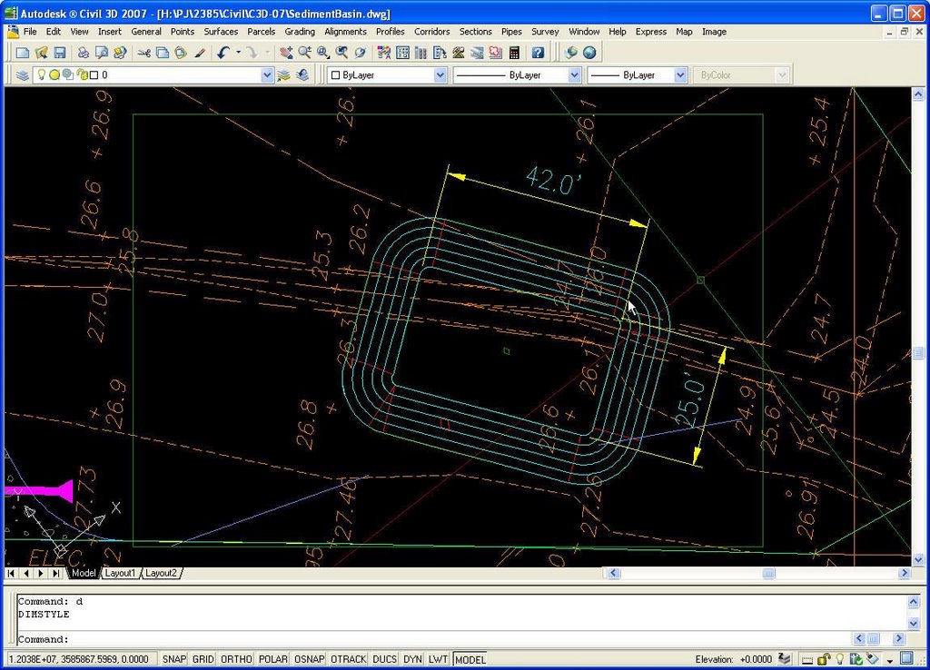
Calculating volumes for ponds and sediment traps is even easier now with the new grading utilities in Civil 3D. But if you're an experienced Land Desktop user, the grading objects do not react quite like they used to. Be careful not to leave out the surface definition for the bottom of the pond. In Land Desktop, the grading objects defined TIN lines for the pond bottom for you. LDT objects connected the TIN at the bottom. Civil 3D gradings may not depending upon how they are defined. For instance, look at this example.
Here we have defined our pond bottom as a 42' x 25' rectangular feature line set at elevation 20.0'.
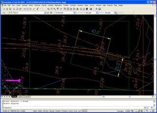
Then we add a grading with 2:1 slopes up to elevation 25.0'. The grading will automatically create my surface "SedBasin".
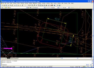
Also, define a surface called "Storage" by using a rectangular feature line and set it's elevation to 25.0'(see the green rectangle surrounding the pond in the previous view). This will give you a comparison surface for volume calculation.
Then calculate your pond volume (located in the 'Surfaces' pull-down menu, Utilities --> Volumes...).
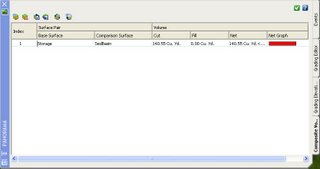
About 140 CY of storage, great. But wait. Let's manually check this.
Our pond bottom is roughly 42' x 25', or 1050 SF. Using the 2:1 slope, the pond top is roughly 62' x 45', or 2790 SF. The average surface area is [(1050 + 2790) / 2], or 1920 SF. A pond 5 feet deep like ours should have an estimated volume of around 1920 SF X 5 Feet = 9,600 CF, or about 356 CY. Well this does not compare with our volume from Civil 3D! What happen? We did not "Infill" the bottom of the pond, therefore there is a hole from the bottom to the top of the pond within the bottom surface area. Only the area within the side slopes is being calculated.
Let's correct.
Use the "Create Infill" option to create a pond bottom infill
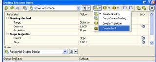
and Select a point inside the pond. The Infill is represented by the Green diamond symbol within the center of the pond.
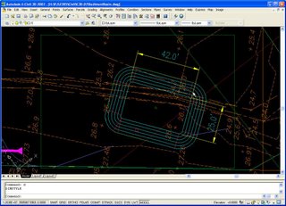
Now use the "Refresh" button to update the pond volume
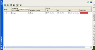
Now we're cooking! 334 CY compares favorably with our manual calculation of 355 CY.
Now if you need stage volumes at elevations 21, 22, 23, and 24, then just revise the elevation of the feature line which defines the "Storage" surface using the "Feature Line Editor" and "Refresh" the volume each time you change the stage elevation. The "Cut" volume will be your storage volume at that elevation. The "Fill" volume may be ignored for this calculation.
Here we have defined our pond bottom as a 42' x 25' rectangular feature line set at elevation 20.0'.
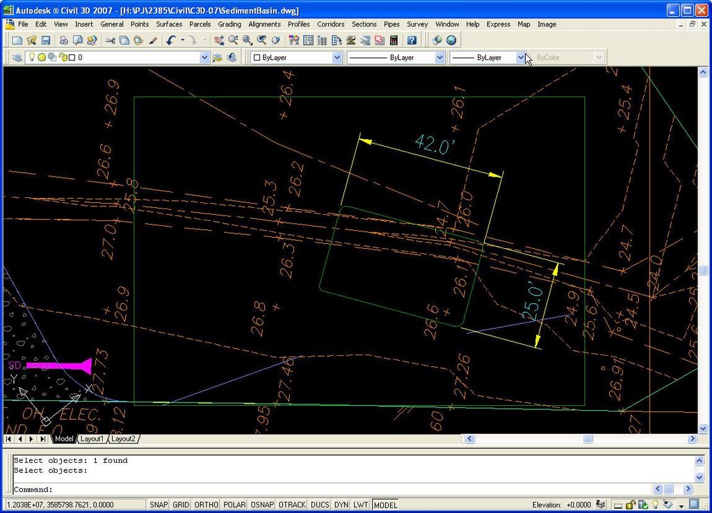
Then we add a grading with 2:1 slopes up to elevation 25.0'. The grading will automatically create my surface "SedBasin".

Also, define a surface called "Storage" by using a rectangular feature line and set it's elevation to 25.0'(see the green rectangle surrounding the pond in the previous view). This will give you a comparison surface for volume calculation.
Then calculate your pond volume (located in the 'Surfaces' pull-down menu, Utilities --> Volumes...).
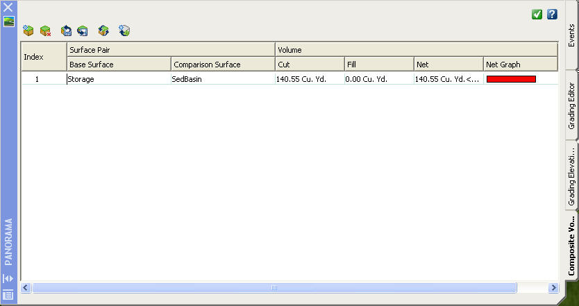
About 140 CY of storage, great. But wait. Let's manually check this.
Our pond bottom is roughly 42' x 25', or 1050 SF. Using the 2:1 slope, the pond top is roughly 62' x 45', or 2790 SF. The average surface area is [(1050 + 2790) / 2], or 1920 SF. A pond 5 feet deep like ours should have an estimated volume of around 1920 SF X 5 Feet = 9,600 CF, or about 356 CY. Well this does not compare with our volume from Civil 3D! What happen? We did not "Infill" the bottom of the pond, therefore there is a hole from the bottom to the top of the pond within the bottom surface area. Only the area within the side slopes is being calculated.
Let's correct.
Use the "Create Infill" option to create a pond bottom infill

and Select a point inside the pond. The Infill is represented by the Green diamond symbol within the center of the pond.
Now use the "Refresh" button to update the pond volume

Now we're cooking! 334 CY compares favorably with our manual calculation of 355 CY.
Now if you need stage volumes at elevations 21, 22, 23, and 24, then just revise the elevation of the feature line which defines the "Storage" surface using the "Feature Line Editor" and "Refresh" the volume each time you change the stage elevation. The "Cut" volume will be your storage volume at that elevation. The "Fill" volume may be ignored for this calculation.
Tuesday, October 03, 2006
Data Shortcuts Revisited
Civil 3D life sure is tough when you don't have the tools to properly do data management. At least that's the way I see it in the life outside of Autodesk Vault. Our company has been holding off on implementing Vault until we see what becomes of it. There had been some rumors about Vault being implemented as part of a future release of Revit Building. That would have gotten our Architectural department fired up about Vault and would have certainly started the ball rolling towards purchasing the required hardware and software (Windows server, MQSQL server, etc., etc.) required to run a corporate-wide Vault system. But now as it stands, the Revit / Vault tie-in seems unlikely to happen. So needless to say, data management has been virtually non-existent for us in the Civil 3D world. Sharing data in Land Desktop was cumbersome enough. And "manually" trading LandXML files back-and-forth between our user base in my opinion is a step backwards and just doesn't make the cut. Yes it can be done, but there's got to be a better way (without Vault).
So back to the future. The good folks at Autodesk have decided to include a "not so old" favorite back into the their system - Data Shortcuts are BACK!!! Or at least they will be in the near future. Dan Philbrick of the Autodesk Civil 3D development team posted in his blog entry of 9/29/2006 that Data shortcuts will be reintroduced in an upcoming release. All I have to say in my best Napoleon Dynamite voice is, "Sweet!". This means that a method that we've been trying to use, as described in a post on Angel Espinoza's blog entitled Civil 3D 2007 - Data Shortcuts, will most likely work again in some form or fashion like it did in previous versions.
A Beta of the "Data Shortcuts enabled-version" is due to be released soon and will be available for download and testing to those who contact the Autodesk development team. Also, more details will be discussed during this Friday's C3D webcast (10/6/2006).
So back to the future. The good folks at Autodesk have decided to include a "not so old" favorite back into the their system - Data Shortcuts are BACK!!! Or at least they will be in the near future. Dan Philbrick of the Autodesk Civil 3D development team posted in his blog entry of 9/29/2006 that Data shortcuts will be reintroduced in an upcoming release. All I have to say in my best Napoleon Dynamite voice is, "Sweet!". This means that a method that we've been trying to use, as described in a post on Angel Espinoza's blog entitled Civil 3D 2007 - Data Shortcuts, will most likely work again in some form or fashion like it did in previous versions.
A Beta of the "Data Shortcuts enabled-version" is due to be released soon and will be available for download and testing to those who contact the Autodesk development team. Also, more details will be discussed during this Friday's C3D webcast (10/6/2006).
Tuesday, September 12, 2006
Q = ciA
Hopefully this will be one of the equations Autodesk solves for in their next release of Civil 3D. I'm telling you...wouldn't it be nice to be able to overlay land use information over drainage area polygons to extract weighed "C" values per basin? Then add in the terrain surface model to determine the most hydraulically distant point within each catchment area, the travel paths, and have the software figure out time of concentrations (Tc) for overland, shallow concentrated, and open channel sheet flow conditions. Then input rainfall amounts to determine flow amounts per area. Simple rational method calculations you know. Then have a print out in a nice LandXML formatted report. Now that my friends would be a huge step closer to the Holy Grail and would begin to make that second "D" in CADD grow just that much larger.
Oh BTW, I apologize for not posting more often. You folks who read the Civil 3D newsgroup may have seen a thread concerning the issues that I've been having with Service Pack 2 and the Pipes options. Unfortunately, I think my final answer is to wipe my system clean and start fresh with a clean Windows OS install. Go figure. And out of a few computers which have been upgraded at my office, mine is the only one not to work. Must be that mediaWiki install that I did a while back using Apache web server, PHP, and MySQL. C3D Pipes may have not liked that, but at this point, that is only a guess. It's pretty much the only thing I haven't uninstalled from the system to troubleshoot my Pipes problem. If I find out what is causing the issue, I'll post it here (and the newsgroup).
Oh BTW, I apologize for not posting more often. You folks who read the Civil 3D newsgroup may have seen a thread concerning the issues that I've been having with Service Pack 2 and the Pipes options. Unfortunately, I think my final answer is to wipe my system clean and start fresh with a clean Windows OS install. Go figure. And out of a few computers which have been upgraded at my office, mine is the only one not to work. Must be that mediaWiki install that I did a while back using Apache web server, PHP, and MySQL. C3D Pipes may have not liked that, but at this point, that is only a guess. It's pretty much the only thing I haven't uninstalled from the system to troubleshoot my Pipes problem. If I find out what is causing the issue, I'll post it here (and the newsgroup).
Tuesday, August 01, 2006
Revit Civil?
I saw a demonstration of Revit Building today by one of our Electrical designers and I got to thinking; why don't the Architectural / Building Systems and Civil software developers at Autodesk coordinate more with each other? Revit has a pretty slick user interface and I could definitely see working with Civil 3D in that environment.
Also, it would seem like Autodesk would want to streamline their building and infrastructure product lines into one system: Revit Building, Revit Structure, Revit Systems, and of course "Revit Site" could replace Civil 3D.
Civil engineers would not be the only ones who would benefit. Electrical and Mechanical engineering types also have design elements related to site work - lighting, power and commuications ductbanks, gas mains, steam lines just to name a few. The Civil techs usually "get stuck" with doing the electrical and mechanical site work, especially developing profiles, because they are the ones who are most familar with working with site plans. Why not share the wealth by extending this functionality into Revit, and therefore somewhat merging the projects so they are more compatible?
Architects could also use the site model from "Revit Site" to perform 3D visualizations and analysis in a more compatible, flexible, and "coordinated" environment. (emphasis here on the use of "coordinate" d ).
I was impressed by the features of Revit from what I saw in the brief demo. I believe it could most definitely translate over to the Civil side. If you ever get the chance to attend a Revit seminar, I'd highly recommended it, if only just to see want the "other side" is up to.
Also, it would seem like Autodesk would want to streamline their building and infrastructure product lines into one system: Revit Building, Revit Structure, Revit Systems, and of course "Revit Site" could replace Civil 3D.
Civil engineers would not be the only ones who would benefit. Electrical and Mechanical engineering types also have design elements related to site work - lighting, power and commuications ductbanks, gas mains, steam lines just to name a few. The Civil techs usually "get stuck" with doing the electrical and mechanical site work, especially developing profiles, because they are the ones who are most familar with working with site plans. Why not share the wealth by extending this functionality into Revit, and therefore somewhat merging the projects so they are more compatible?
Architects could also use the site model from "Revit Site" to perform 3D visualizations and analysis in a more compatible, flexible, and "coordinated" environment. (emphasis here on the use of "coordinate" d ).
I was impressed by the features of Revit from what I saw in the brief demo. I believe it could most definitely translate over to the Civil side. If you ever get the chance to attend a Revit seminar, I'd highly recommended it, if only just to see want the "other side" is up to.
Tuesday, July 25, 2006
CIVIL 3D ROCKS: Eliminating the "Pseudo Sump" on Structures Civil 3D 2006 and 2007
Here's how to remove an unwanted sump within a structure by creating and setting a floor thickness equal to 0.
CIVIL 3D ROCKS: Eliminating the "Pseudo Sump" on Structures Civil 3D 2006 and 2007
CIVIL 3D ROCKS: Eliminating the "Pseudo Sump" on Structures Civil 3D 2006 and 2007
Monday, July 24, 2006
Civil 3D update
Our Civil 3D implementation is progressing here at Clark Nexsen. We are slated to have 20 members from our Civil Engineering department trained on the product by an outside consulting firm, Inlet Technology, near the end of August. Should be interesting. In the meantime, I've been using the software with success on a couple of large grading projects for the U.S. Army Corps of Engineers. I've found a couple of bugs/issues which Autodesk promptly helped me with through the use of the Civil 3D newsgroups. Thanks Autodesk!
Also, trying to get the styles created for our Imperial and Metric templates. It's a slow process when you really don't have time for it and projects have deadlines which are more important. Gotta' pay the bills. Anyway, we're getting there.
Also, trying to get the styles created for our Imperial and Metric templates. It's a slow process when you really don't have time for it and projects have deadlines which are more important. Gotta' pay the bills. Anyway, we're getting there.
Subscribe to:
Posts (Atom)